Search
Feeds
Archives
About
Links
TerraceM in GEOSPHERE
Check the latest publication of TerraceM in GSA Geosphere
Wednesday 23 December 2015 at 3:19 pm. Used tags: geosphere, marine, terracem, terracesCheck the latest publication of TerraceM in GSA Geosphere:
TerraceM: A Matlab(R) toot to anlyze marine and lacustrine terraces using high-resolution topography.
published online on 23 December 2015. Geosphere
TerraceM is now in GSA Geosphere.
Along this paper we present TerraceM, an user-friendly GUI programed in MATLAB(R) to analyze marine and lacustrine terraces using high resolution topography. TerraceM uses several tools to obtain accurate measurements of the shoreline angle, a geomorphic feature that can be correlated with past sea-levels positions. TerraceM enable processing series of swath profiles from several sites in an efficient and structured workflow. We believe that TerraceM will help to expand and facilitate regional studies of marine and lacustrine terraces.
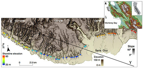
Example of staircase terrace analysis in Santa Cruz, California (Jara-Muñoz et al., 2015. GSA Geosphere).
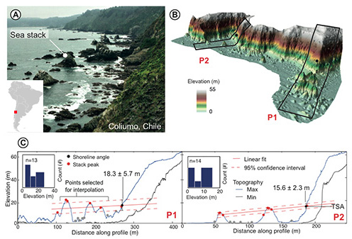
Example of rough coasts analysis in Coliumo, Chile (Jara-Muñoz et al., 2015. Quaternary Science Reviews. U. Potsdam).