Search
Feeds
Archives
About
Links
Backgrounds
Backgrounds of marine and lacustrine terraces
Wednesday 19 August 2015 at 07:38 am.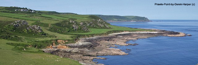
(Modified fragments and figures from Jara Muñoz et al., 2016, Geosphere)
Coastal landscapes are shaped by the combined effects of tectonic uplift, sea-level changes, and surface erosion. Marine terraces are temporary coastal landforms characterized by relatively flat, gently seaward-dipping platforms bounded inland by scarps or paleo-cliffs that separate different terrace levels (Fig. 1). These landforms typically form during sea-level highstands (Lajoie, 1986; Anderson et al., 1999), when wave erosion actively cuts platforms into rocky coasts. As waves erode the base of coastal cliffs, they carve wave-cut platforms while cliffs retreat landward (Challinor, 1949; Sunamura, 1983; Trenhaile, 2000). During subsequent sea-level lowstands, terraces may be modified by river incision, cliff diffusion, or burial by eolian sediments. Over tens of thousands of years, continued tectonic uplift can preserve these former shorelines, producing the characteristic staircase sequences of marine terraces observed along many active coasts (Guilcher et al., 1986; Regard et al., 2010; Pedoja et al., 2014; Jara-Muñoz and Melnick, 2015).
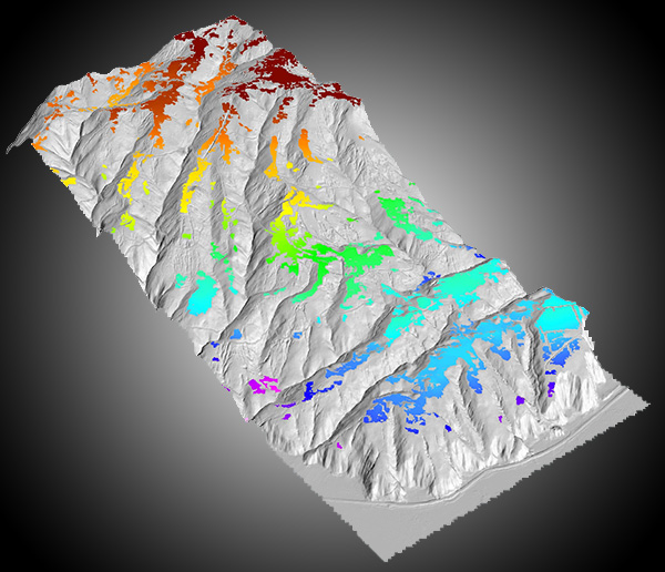
Marine terrace elevations are commonly estimated from their surface morphology and used to infer the amount of tectonic uplift since terrace formation. Several geomorphic markers and methods have been used to determine terrace elevation (Fig. 2). A common approach is to identify the terrace inner edge—the break in slope at the base of the paleo-cliff—along topographic profiles (e.g., Armijo et al., 1996; Saillard et al., 2009; Regard et al., 2010; Roberts et al., 2013). More automated techniques use high-resolution digital terrain models (DTMs) to detect terrace platforms based on terrain slope and surface roughness (e.g., Palamara et al., 2007; Bowles and Cowgill, 2012). Because different markers and methods may be used, terrace elevations—and the uplift rates derived from them—can vary significantly.
The shoreline angle represents the position of sea level at the time a marine terrace formed (Lajoie, 1986). In modern coasts it occurs at the base of the sea cliff, while in uplifted terraces it is typically located near the intersection between the paleo-cliff and the paleo-platform (Fig. 2D). Because it approximates former sea level, the shoreline angle is commonly used to estimate tectonic uplift. Uplift rates can be calculated as: Ur = (Te − Sl) / t (Lajoie, 1986) or Ur = Te / t (Pedoja et al., 2008) where Te is the present terrace elevation, Sl the sea level at the time of formation, and t the terrace age. Assuming Sl = 0 simplifies the calculation and avoids uncertainties related to sea-level corrections, but it may introduce bias in areas with low uplift. In all cases, uplift estimates strongly depend on the accuracy of terrace elevation measurements.
Estimating terrace elevation is challenging because deformation markers can vary in time and space. For example, the inner edge identified from slope maps (Palamara et al., 2007) often marks the contact between colluvium and the paleo-cliff, which lies higher than the actual shoreline angle (Matsu’ura et al., 2014). Similarly, surface classification models (SCM) used to map terrace platforms (Bowles and Cowgill, 2012) can underestimate uplift rates, as these markers often form below the high-stand sea level before cliff retreat is complete. Because different markers can give disparate uplift estimates with large uncertainties, the shoreline angle remains the most reliable indicator for calculating uplift, as it directly reflects the former sea level (Lajoie, 1986).
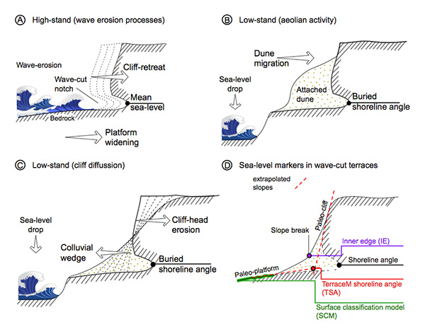
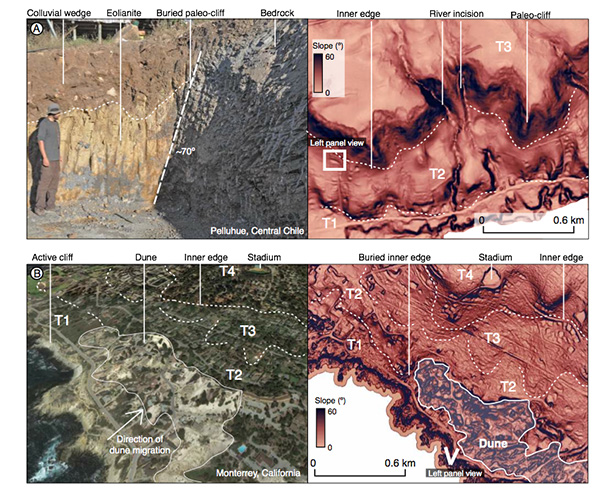
The shoreline angle of uplifted marine terraces is often hidden when paleo-cliffs or platforms are affected by scarp diffusion, river incision, or eolian deposits (Figs. 2B, 2C, 3A–3D). a) Scarp diffusion can obscure the shoreline angle, but it also allows estimation of the geomorphic age of the cliff (Kt). Studies using fault and terrace scarps have shown how erosional processes gradually smooth cliffs over time (Wallace, 1977; Bucknam and Anderson, 1979; Hanks et al., 1984; Avouac, 1993). Models assume that material moves downhill at a rate proportional to the slope, with the removed material accumulating at the base. Over time, this reduces the cliff slope and can bury the shoreline angle under colluvium (Fig. 2C). The geomorphic age of the paleo-cliff can then be estimated by comparing observed topography with diffusion models.
Mass transport equation (Hanks, 1984): M= -K(δu/ δx) Eq. (3)
Proportionality constant (Hanks, 1984): K=k / ρ Eq. (4)
b) River incision is controlled by changes in the erosive base level, which along coasts is usually the sea level (Bishop et al., 2005). Most incision on terrace surfaces occurs during sea-level lowstands, when rivers have higher stream power (Talling, 1998). These cycles create retreating knickpoints that propagate base-level changes through river networks (Crosby and Whipple, 2006; Loget and Van Den Driessche, 2009). Over time, incision gradually erodes paleo-platforms and paleo-cliffs, progressively modifying terrace morphology (Figs. 1, 3A).
c) Sediment transport along coasts shapes rocky platforms or sandy beaches depending on shoreline morphology, sediment supply, tidal range, and wave exposure (Trenhaile, 2001; Ruz and Meur-Ferec, 2004; Twidale et al., 2005). Eolian processes intensify during sea-level lowstands as the coastline retreats (Bradley and Addicott, 1968; Cantalamessa and Di Celma, 2004; Masselink et al., 2014), forming coastal dunes that migrate inland (Bailey and Bristow, 2004; Carr et al., 2006). These sediments can cover terrace platforms and climb paleo-cliffs, obscuring terrace morphology and burying the shoreline angle (Figs. 2B, 3B).
Marine terraces have been compared worldwide to understand their origin and the development of uplifted paleo-coasts in the context of sea-level history (Pedoja et al., 2014). However, the effects of erosion and sediment accumulation on terrace morphology—and their impact on uplift and deformation estimates—have not yet been fully quantified. To address this, we developed TerraceM, a tool that allows users to:
A) Analyze and separate erosive and depositional processes that can mask the shoreline angle,
B) Extract shoreline angles continuously along terrace exposures using many profiles, and
C) Quickly visualize results and export data to other software platforms.
(Modified fragments and figures from Jara Muñoz et al., 2016, Geosphere)
