Search
Feeds
Archives
About
Links
TerraceM tools
Modules included since the release of TerraceM-2
Tuesday 18 August 2015 at 07:10 am.TerraceM-2 tools
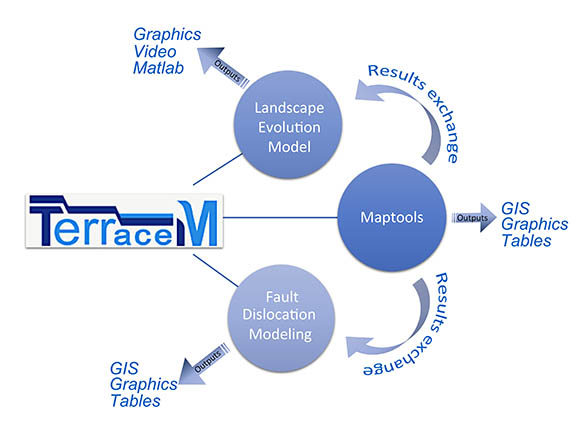
TerraceM is a Matlab tool that is constantly evolving and improving, the latest TerraceM release include three modules, for mapping and modelling marine and lacustrine terraces, designed to be used both as independent and complementary GUI’s interchanging data between them.
.
- TerraceM Maptools (MT) module:
This is a Graphical user Interface (GUI) designed to interactively map marine and lacustrine terraces using swath profiles and surface classification models. The module also iclude ancillary tool for visualization and exporting data in different formats.
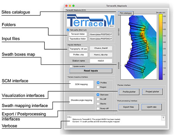
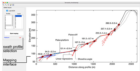
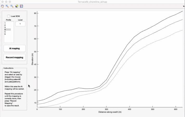
- Swath profile mapping
The swath profile mapping interface is an improved GUI that allows mapping and visualizing shoreline angles. TerraceM-2 uses the maximum elevations of swath profiles, which resemble the original coastal terrace morphology without the effects of post-abandonment modification, principally resulting from fluvial incision.
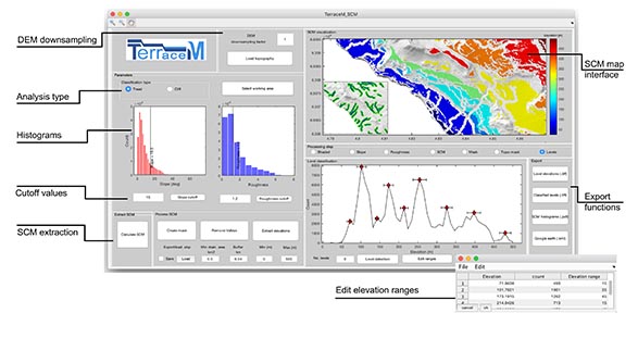
- Surface classification model
The second mapping method of TerraceM-2 MAP is based on Surface Classification Models (SCM), designed to semi-automatically detect low-relief and gently inclined smooth areas, often associated with coastal terrace paleo-platforms and steeper areas that may represent terrace paleo-cliffs. The SCM is based on the method developed by Bowless & Cowgill (2012) that uses a combination of topographic slope (SLP) and roughness (RG), the former being defined as the standard deviation of the slope (Frankel and Dolan, 2007).
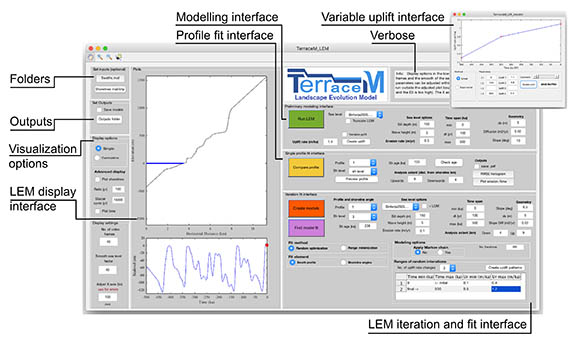
- TerraceM Landscape Evolution Model (LEM) module:
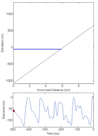
The TerraceM-2 LEM has been adapted from the wave erosion and energy dissipation model initially formulated by Sunamura (1992) and further developed by Anderson et al., (1999). This model has been already used to simulate the development of drowned shorelines in southern Chile (Jara-Muñoz et al., 2017), rasa surfaces in northern Chile, (Melnick, 2016) as well as staircase marine terrace sequences in Turkey (Racano et al., 2019). The model simulates the morphology of wave-cut terraces formed under oscillating sea level conditions and variable or constant uplift rates. The erosive power of wave abrasion is defined as a linear function of the rate of wave energy dissipation that follows an exponential increase as depth decreases landwards (Sunamura, 1992).
Example animation of marine terraces generated with TerraceM LEM
.
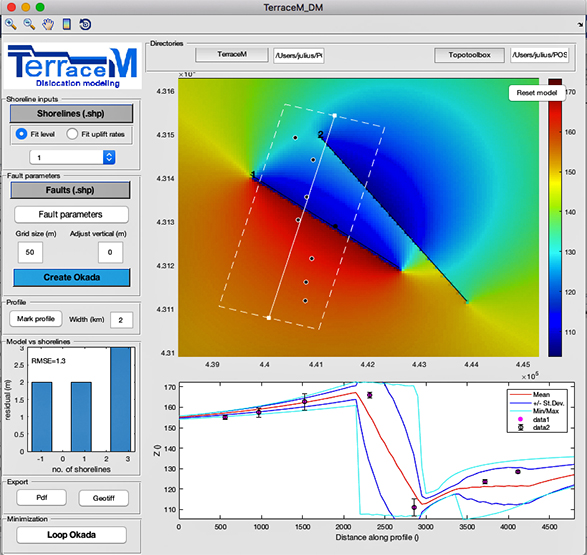
- TerraceM Dislocation Model (DIM) module:
Active faults in coastal areas may produce local relative sea-level changes, surface ruptures, and increasing the magnitude and arrival times of tsunami waves (e.g. Jara-Muñoz et al., 2017; Melnick et al., 2012; Wendt et al., 2009). Therefore, identifying seismically active structures and estimating their slip rate are crucial to assess the spatial and temporal characteristics of seismic hazards in coastal areas. TerraceM-2 includes a novel routine to model fault dislocations and surface deformation based on the spatial distribution of coastal terrace elevation or uplift rates. TerraceM DIM is based on the fault-dislocation theory of Okada (1985) that provides an analytical solution for surface deformation resulting from slip along a fault in a homogeneous elastic half-space.
TerraceM-3 Tools
- Automated mapping using machine-learning
TerraceM-3 includes new tools and also updated previous tools. For instance, the Terrace_MAP module released in TerraceM-2 now includes automatic mapping. TerraceM-3 enables users to reduce non-systematic and systematic errors in terrace mapping by integrating machine learning techniques to replicate human mapping criteria.
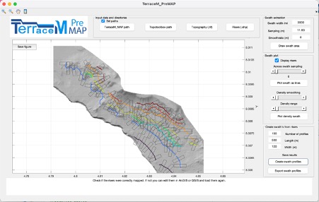
- TerraceM_PreMAP
TerraceM_PreMAP allows to handle systematic errors originating from wrong marine terrace correlations. that follows a systematic approach. TerraceM_PREMAP allows for for checking and correcting the inner edge mapping process and lateral correlations. The module enables comparison between the mapped inner edges and an innovative variant of topographic profile display defined as ‘Stacked Swath’, which is based on stacked parallel profiles
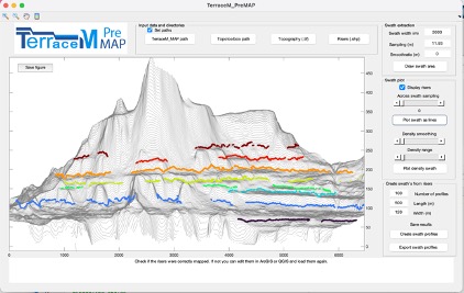
Examples of Stacked swath and semi-automated swath profile creation at Cerro el Huevo, Peru
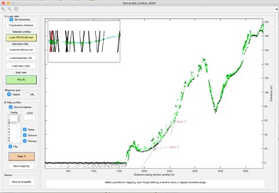
- TerraceM_ICESat_Process
In several regions, the availability of high-resolution topographic data remains relatively scarce limiting precision in geomorphic marker mapping. TerraceM-3 introduces a new module for downloading, filtering, and processing centimeter-resolution topographic data from the ICESat-2 satellite at global scale.
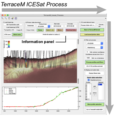
- TerraceM_ICESat_MAP
The TerraceM-ICESat module produces vegetation-free profiles ready for assisted machine-learning mapping into a graphical user interface.
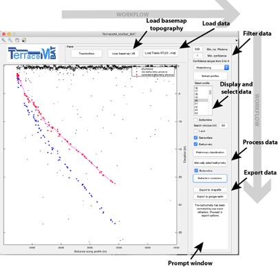
- TerraceM_ICESat_BAT
Shallow bathymetry may be also extracted to extend the mapping of drowned terraces offshore.